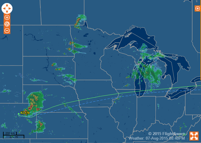
A Boston TV station interviewed me regarding Delta 1889, an Airbus A320 scheduled from Boston to Salt Lake City that encountered hail and diverted to Denver. Below is the big picture of NEXRAD data that one can see from a web browser and the plane’s track over the ground. The big picture is available for free to anyone with a web browser. Adding that capability to a little Cessna costs about $10,000 for the FAA-certified XM radio ($100 for a car?) and about $600 per year for the data subscription from XM. How much would it cost to put this $100 XM radio in a Boeing or Airbus? The regulator hurdles are so high that it would almost surely not be affordable to airlines. Therefore they rely on onboard weather radar that can see rain out the front plus advice from air traffic controllers who have at least local NEXRAD data on their radar screens.
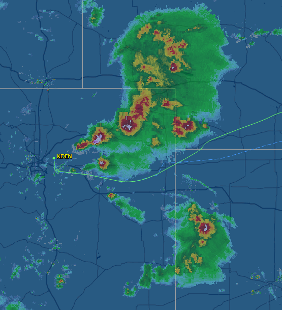
Without the big picture the pilots would have had a tough time seeing that the space between thunderstorms was tight (the FAA says don’t get any closer than 20 nautical miles to a thunderstorm for fear of hail and turbulence, but that is just a rule of thumb) and that going south to Oklahoma or north through the top of Kansas would have been more prudent. Their onboard radar reflects wonderfully off rain but not so well from the dry baseball-sized hail that they encountered.
The primitive nature of electronics for aircraft was on full display during this incident. The pilots of Delta 1889 had cracked windshields that could have blown out at any moment, causing a depressurization. Their onboard radar was destroyed. But there was no way for them to have a dedicated communication channel to ATC. The controllers had to keep talking to other airplanes on the party line and giving what attention they could to the airplane with the emergency. (liveatc recording)
The pilots quite sensibly picked Denver, an airport with crazy long runways (one is 16,000′ long!). It is easy to fly any instrument-certified airplane, including an A320, down to about 200′ above the ground without being able to see out the windows. The final 200′ usually requires visual identification of the runway. However, due to their spectacularly foggy/misty weather, the British decided to build autoland systems starting in the 1960s. The typical domestic airline won’t maintain and test autoland to the extent required to make it legal to use day-to-day. Where autoland becomes a factor in the U.S. is for transoceanic flights. With the potential ability to land in fog they can cut down on the amount of reserve fuel that must be carried. However, even if autoland is not maintained and tested all the time it remains available to use and the pilots of Delta 1889 did use it (receiving a “nice job” from the control tower).
The pilots were heroes to everyone (including me, I think, since they sounded so cool on the radio after escaping the hail). But why weren’t the engineers who designed the windshields and the autoland system celebrated? Who went over to France to find the programmer behind the A320 autopilot and autoland system? Who found the glass manufacturer to find out how their product survived the pounding without subjecting passengers to depressurization?
There’s really no need for an XM subscription in the United States if you want to see the strategic weather picture. The free ADS-B datalink system provides the same data for display on a tablet computer via a ~$500 receiver.
With respect to bird windows, I used to be a navigator on F-111 Aardvarks. That airplane could fly at M1.5 at 200 feet agl. In training a big deal was made about the ground breaking work Corning glass to develop our nice big canopy windows that could take bird strikes at these very high speeds.
Jim: As noted in http://philip.greenspun.com/flying/pc-12/review , the ADS-B system doesn’t provide data for the whole country the way that the XM system does. It seems to be designed for Cessna 172s and similar speed aircraft. The RADAR picture doesn’t seem as detailed or complete as from XM but maybe that is just presentation software.
The ADS-B uplink is sending the exact same NEXRAD data as that sent by satellite weather providers. The only real difference is that the ADS-B weather radar presentation is sent at lower resolution for weather further than 250 nm from the current aircraft position.
In fact ADS-B is really designed for high altitude aircraft, especially in the Western United States, because due to terrain there are large gaps below 3000-5000 feet agl due to ground antenna placement.
A Cessna 172 probably benefits more from satellite weather than a jet.
And of course XM does not provide the traffic information that is so nice to get from ADS-B.
There are slight differences in what products are provided by ADS-B and the two data providers used by ‘SiriusXM Aviation Weather’ and the ‘XM WX Satellite Weather’ (these are holdovers from when Sirius and XM were different companies), but the core weather data pilots want are available in all three systems.
There is some risk that one of the two XM/Sirius satellite systems could be shut down by the provider at some point in the future, so guess correctly or regret your choice.
I’ve flown with both systems. I think XM does update a bit faster, but not enough to matter much. Neither XM or ADS-B weather should be used for tactical weather avoidance, that’s what onboard weather radar is for.
Jim: Since you seem to know a lot about ADS-B… why isn’t it possible to get METARs and TAFs for far-away airports? Is the bandwidth much lower on ADS-B than on XM? With XM we could keep checking destination actual weather throughout a flight. With ADS-B we can’t see the METAR until we’re within maybe 100-150 nm. (ADS-B does have text data for the huge airports, e.g., JFK or SFO, but not the ones that we would be going to in a private plane.) What is the actual datalink bandwidth for ADS-B? There is presumably a broadcast channel, right?
ADS-B provides METARS 250-500nm from own ship, XM does provide nationwide METARS.
On the other hand, ADS-B provides NOTAM data with 100nm of ownship, XM doesn’t provide NOTAMS.
Jim: But why is ADS-B limited in this way? The total METAR stream can’t be more than a few kbps.
XM data rate is significantly higher than ADS-B, and the priority for ADS-B is traffic. Weather, NOTAMS, TFRs, etc are of secondary importance.
It’s interesting that ADS-B can in fact carry a lot more data than is currently being used. For example newish airliners transmit autopilot altitude settings, but I don’t think any ATC anywhere is using that yet.
When that German Wings pilot committed suicide, a commercial service, http://www.flightradar24.com, which monitors ADS-B to feed their webpage, was able to recover the altitude change command that result in the crash.
METAR bandwidth is trivial. I just replayed ADSB log I recored from my couple days old flight from KHPN to KBED and within couple minutes of takeff I had metars as far as 938 NM. KNPA Reported good weather.
METAR bandwidth is trivial. I just replayed ADSB log I recored from my couple days old flight from KHPN to KBED and within couple minutes of takeff I had metars as far as 938 NM. KNPA Reported good weather. And it was pretty far
I fly for an airline that has reasonably reliable and fast WiFi in our aircraft now, and company issued iPads with a pretty good WSI weather app upon which I can overlay my flightpath. The weather data is Nexrad quality along with cell tops, and the updates are every 5 minutes.
No, I can’t use the iPad data for tactical weather avoidance, but more than once I’ve been able to analyze the big picture over many hundreds of miles and make the choice to go well around a significant area of weather, rather than try to pick my way around or between an area of cells, specifically to preclude an incident like Delta had.
The combination of onboard radar along with the big picture on the iPad is an awesome combination for weather avoidance.
Granted they are biased, but Foreflight had similar thoughts as you Phil:
http://blog.foreflight.com/2015/08/14/oh-hail-cockpit-weather-delta-1889/