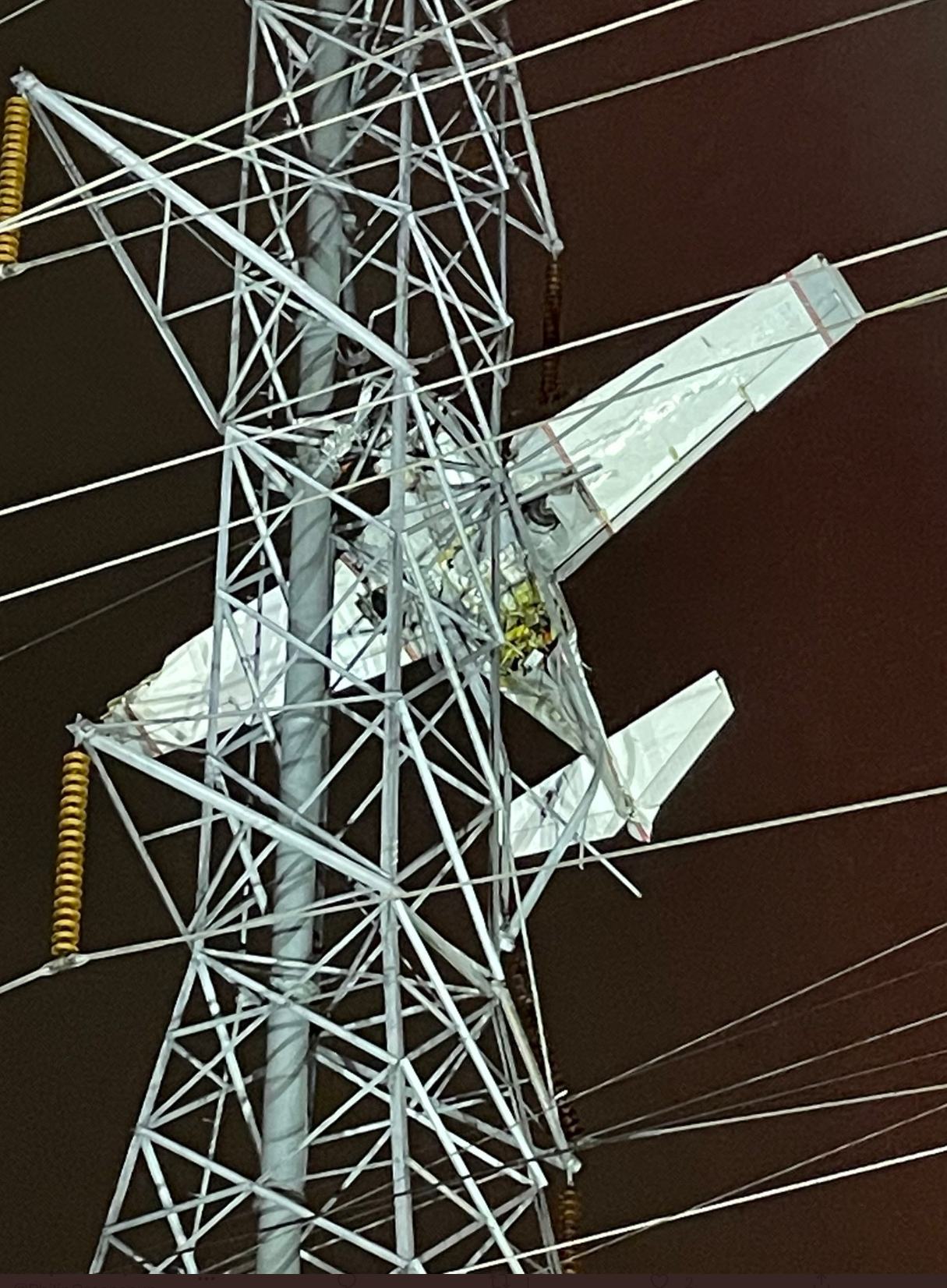
Friends in the D.C. area have been texting me tonight regarding a Mooney that landed in some powerlines near KGAI. From CBS:
A small plane crashed into power lines in Maryland, leaving two people dangling about 100 feet in the air, officials said. The crash knocked out power to thousands of people in the area.
A single-engine Mooney M20J crashed into wires near Montgomery County Airpark in Gaithersburg, Maryland, around 5:40 p.m. local time Sunday, according to the Federal Aviation Administration. The plane appeared to be intact as it was caught in a web of power lines about 100 feet in the air.
As of roughly 7:50 p.m., Montgomery County Fire and Rescue Service spokesperson Pete Piringer said the people aboard the plane were uninured. Earlier he said that they remained in a “very precarious situation,” as the wires were still energized. Utility company Pepco said that as of around 8:30 p.m. the lines had been deenergized.
How could this happen? Mooney pilots are usually pretty good! The plane departed from Westchester County, NY, according to ABC. So the task at Gaithersburg was an attempt to land. Where are these powerlines? Let’s check The Google:
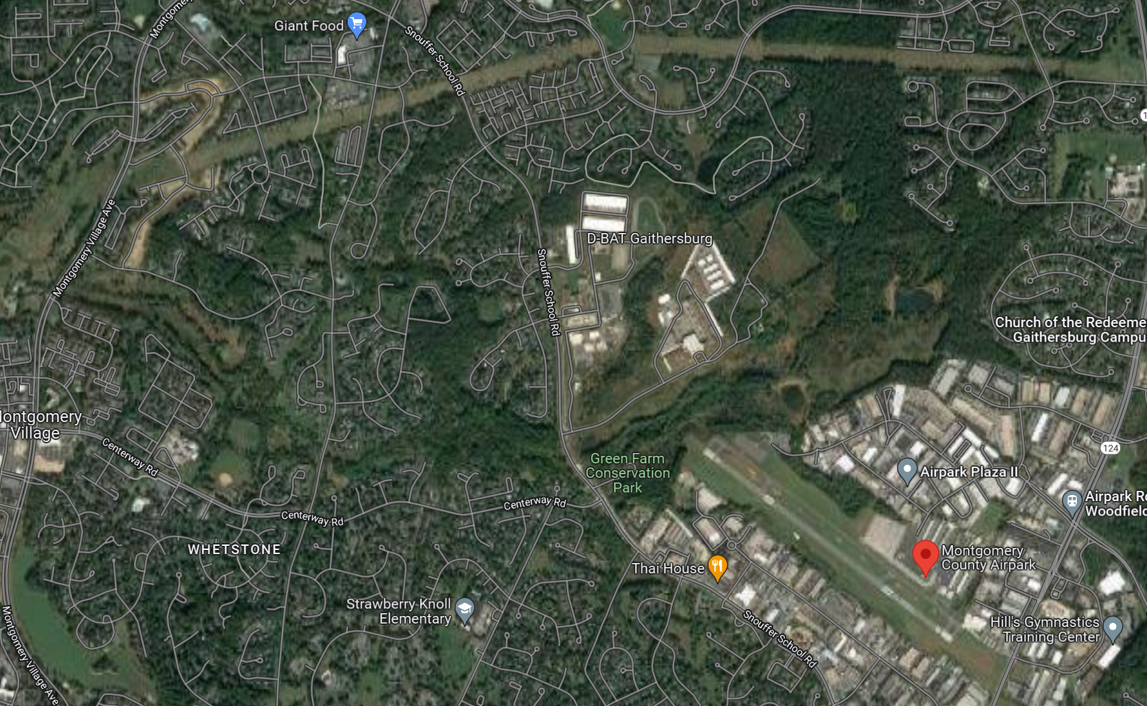
The only tall high-voltage lines that I can see are about a mile from the runway, top left of the above image, rather near Giant Food. That’s quite a distance from the runway to be so low to the ground.
Let’s check the weather. 5:40 pm is 17:40 EST then add 5 hours and we get 2240Z. Here’s are the METARS:
KGAI 272156Z AUTO VRB04KT 1 1/4SM BR OVC002 11/11 A2945 RMK AO2 SLP987 T01060106
KGAI 272128Z AUTO 18003KT 1 1/4SM BR OVC002 11/11 A2945 RMK AO2
KGAI 272121Z AUTO 14006KT 3/4SM BR OVC002 10/10 A2945 RMK AO2
KGAI 272110Z AUTO 14007KT 1 1/4SM BR OVC002 11/10 A2946 RMK AO2
KGAI 272056Z AUTO 15004KT 2SM BR OVC002 11/10 A2947 RMK AO2 PRESFR SLP995 60003 T01060100 56050
Why isn’t there a METAR closer to 2240Z? It seems that the 2256Z observation would have come after the massive power failure. Here’s an observation from nearby Dulles Airport:
KIAD 272252Z 21011KT 1 1/2SM BR OVC003 11/11 A2945 RMK AO2 SFC VIS 9 SLP971 T01110106Could part of the problem be that the altimeter in the Mooney wasn’t set correctly and, therefore, the instruments were showing the plane to be higher than it was? This is an irrelevant factor for an approach with a glide path, which KGAI has. They would have gotten fresh altimeter settings during the entire flight from Air Traffic Control. The departure airport, KHPN, had an altimeter setting of 29.64″ about one hour before accident. So if they’d taken off from HPN and never touched the altimeter they would have been (29.64-29.45)*1000 = 190′ lower than indicated. This kind of mistake resulted in an accident at KBDL to American Airlines 1572 (The NTSB report says that they were on a VOR 15 non-precision (no glideslope) approach.)
The weather was not improving dramatically after 2156Z (4:56 pm). Is it reasonable to land with only 1.25 miles of visibility and 200′ overcast? If you’re a two-pilot crew going into Dulles Airport with its idiot-proof runways and powerful approach lighting system that will cut through the clouds and mist… yes. In fact, the minimums for the ILS 1R at KIAD are 200′ ceiling and 1800′ of visibility.
What about at KGAI? Assuming that this airplane was trying to land, they’d be using the RNAV 14. With the latest and greatest WAAS-capable avionics, the weather minimums are 269′ and 1 mile of visibility. Touchdown zone elevation is 520:
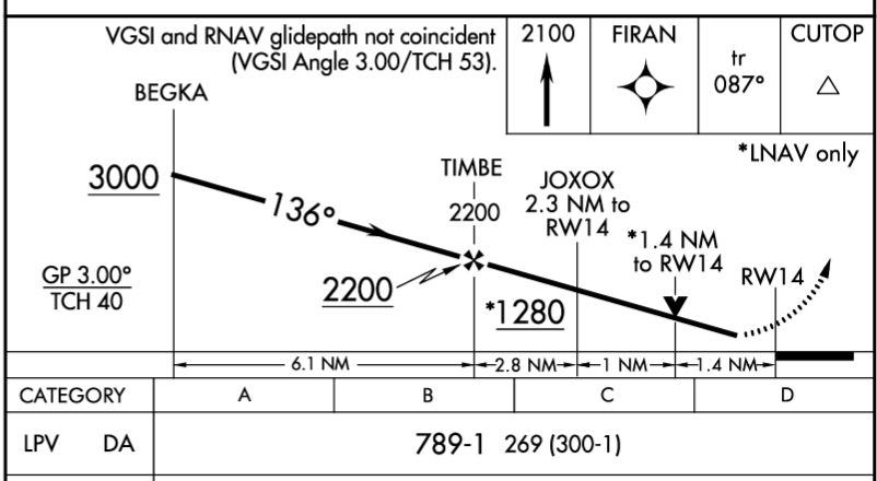
So this would have been an attempt to do the an approach that the weather report suggested could not be accomplished legally. This is actually legal for Part 91 (private) flying, but is not permitted for airlines (Part 121).
On the third hand, had the pilot flown the approach correctly, it should have resulted in a safe landing on the runway even with weather below minimums. Based on my experience, the virtual glide path created by the WAAS GPS box is valid all the way to the ground. (And this was part of our airline training at a Delta subsidiary for ILS approaches; the glide slope (projected via radio waves from the ground) could be used as a reference even after breaking out from the clouds and being within 50′ or 100′ from the runway.) In fact, an autopilot could take the plane down all the way to the runway (would be a rough landing without a flare, but nothing that would be hazardous to the people inside the plane).
So the crash remains something of a mystery at this point. I would want to know if the Mooney (potentially ancient) had a modern WAAS-capable GPS for the RNAV 14 approach. If not, the weather minimum is 400′ ceiling and 1.5 miles of visibility and the challenge for the pilot is substantially greater.
This would be perfect for a Godzilla movie. Godzilla loves powerlines and he is often well-disposed to humanity so he could simply pull the airplane out of the powerlines and set it down on the runway.
Update: I found some relevant Air Traffic Control audio at LiveATC.net. Controllers often speak on multiple frequencies and I found half of a conversation on 128.7 in the archive block starting at 2200Z on 11/27 (so the media reports of a crash at 5:40 pm are probably incorrect; it would have been around 5:28 pm). LiveATC.net captured Potomac Approach, but not the Mooney or other aircraft (so it is likely that the exchanges were happening on a different frequency associated with Potomac Approach; a merged recording of 126.75, 125.52, and 133.85 contains some fuzzy responses from the planes/pilots). The Mooney’s tail number seems to end with “1RF” (One Romeo Foxtrot). At 9 minutes in, the controller suggests (gently) that the 1RF has not followed a previous instruction correctly. At 14:45, the controller says “if you’re able to land at Gaithersburg you can report cancellation…” (i.e., it was foreseen that the weather could be below minimums). At 15:55, a Pilatus PC-12 (“Kronos”) is also going to GAI. At 16:45, the controller mentions, probably to the Pilatus, that a Cheyenne went missed from GAI and was diverting to FDK. At 17:45, the controller acknowledges a communication from 1RF. At 18:30, the controller tells 1RF about traffic and tells 1RF to join the approach. At 20:15, 1RF is cleared for the approach (allowed to descend from previously assigned altitude). At 23:15, 1RF is told to switch to the advisory frequency at the untowered KGAI airport (“CTAF”; used for pilot-to-pilot communication). Just before 27:00 the controller uses the full call sign: N201RF, which is the registration for a 1977 Mooney. Unfortunately, this is to issue a low altitude alert. If indeed the Mooney had switched to the CTAF, the message would not have been heard. Just before 30:00, the controller says “it looks like they made it” regarding the Mooney, but tells the Pilatus that he is waiting to get a cancellation from the Mooney (can’t have two airplanes doing instrument approaches at the same untowered airport at the same time).
My best guess is that the conversation was on 126.75, but the receiver that feeds LiveATC.net is not well-positioned to hear low-altitude planes near KGAI.
Second Update: presidentpicker in the comments below gives us an overlay of the Flightaware ADS-B 3D track and the approach. The tracklog ends at 5:27:20 pm and sadly infers an arrival:

Pilot readers: Before we escaped the Land of Lockdown for the Florida Free State, KGAI was my most common destination airport for trips into D.C. My personal rule was that if the weather wasn’t great I would land at Dulles instead. “Not great” meant winds of more than about 20 knots unless straight down the runway, ceiling below 400′, or visibility of less than 3 miles. I would also go into Dulles if I were arriving after the KGAI FBO closed and I wanted a rental car. The fees at Jet Aviation Dulles or Signature for a single-engine piston aircraft were actually quite reasonable. It’s great to be a skilled pilot, but it is even better to set up a situation in which skills are not required. And there’s nothing wrong with doing an approach to minimums, especially if you’ve set up a two-pilot crew in your little Cirrus, but it doesn’t make sense when one of the world’s largest airports is only 5-10 minutes farther from your ground destination.
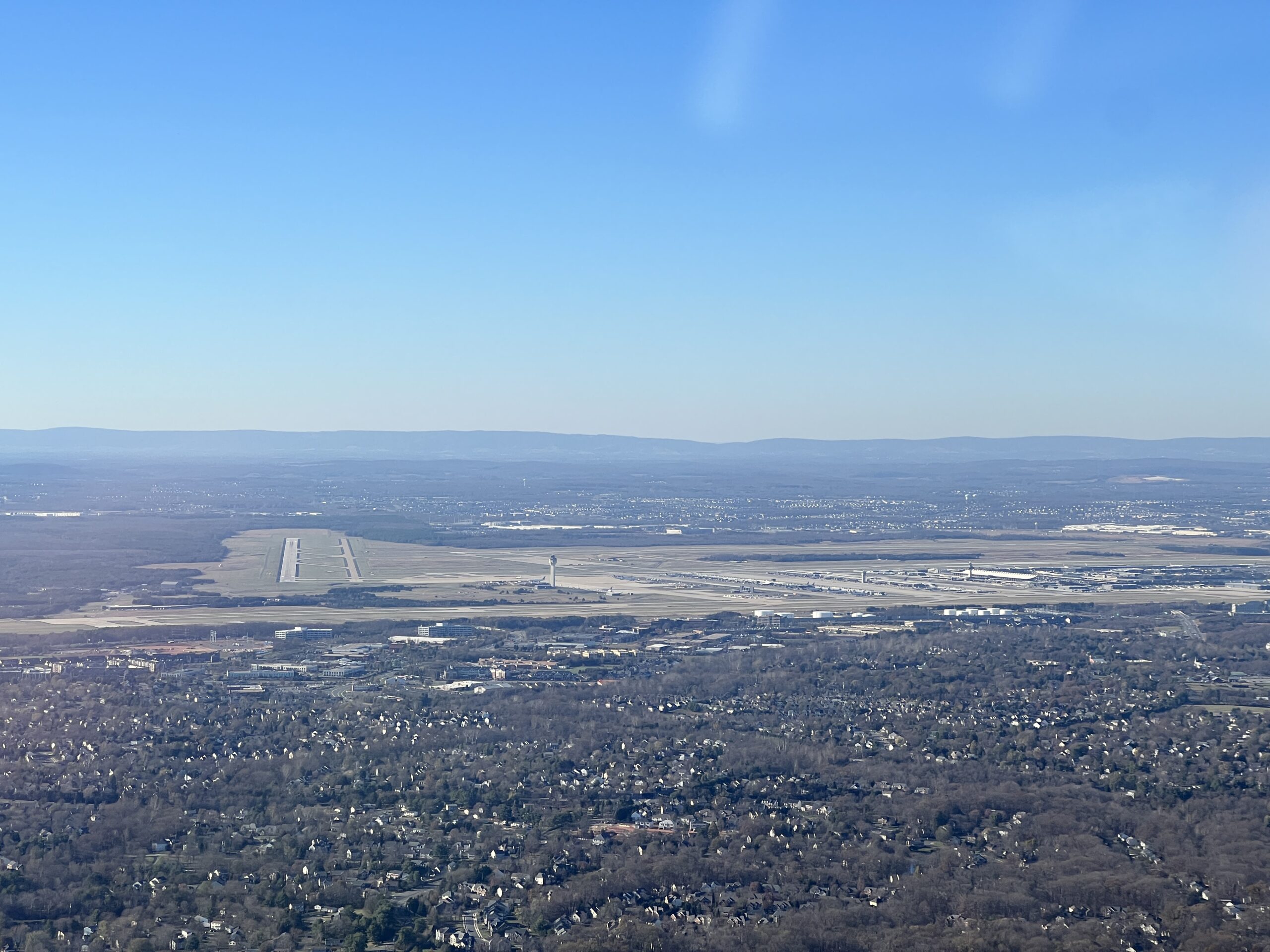
The Dulles photo above was taken just before landing at KGAI last week:

We departed Torrance, California in the Robinson R44 Raven II shown above and landed at Gaithersburg on November 21, 2022. There were a few stops in between…
Related:
Thank you for the comments, I’m assuming the generalization about Mooney pilot’s skills was humor…. or ridiculous. The most likely electrical lines are only 30 FEET ABOVE THE GAI RUNWAY! He was WAY low!
The Mooney has retractable gear and has a tendency to porpoise on landing (pilot-induced). If someone has a few hundred accident-free hours in a Mooney that means more than if he/she/ze/they was flying a Cessna, Piper, or Cirrus (fixed gear, no challenge in flaring/landing).
The powerlines that they hit might be a mile away, actually. I will add a Google Map excerpt to the original post.
Those who live in the vicinity were reporting in comments on various YouTube videos that plane crashed near Giant Food on Goshen Road in Montgomery Village/Gaithersburg, which is about a mile from KGAI.
We can all agree your description of the crash is electrifying! On a separate note I was sad to learn you were in Torrance and didn’t have time to meet up with your favorite bird brained commentator. Please notify the blog the next time you make it to Southern California!!
The same goes for the follower here 10 minutes away from KGAI.
Wow! Great post that you put together so quickly. I’m watching the live feed and fascinated on the engineering discussions that must occur for this rescue. My prayers to all that are in for a long night.
https://youtu.be/1m5wrn3gCq8
I would also encourage those in the area that now have power to charge all devices. I suspect we could see another outage this evening.
Don’t know how an animal survived that without injuries. Instantly stopping from the stall speed should kill anything.
Great post. Our power was knocked out from ~1730 to about 2340. The weather at the crash site has gotten quite foggy since the crash and it wasn’t great there to begin with.
Based on the overlay of the flightaware track on RNAV 14 he was hand flying the approach and, my guess, got unstable.. A reliable autopilot probably would have helped
https://i.imgur.com/SY4evVq.png
Let me link to the flightaware data in the original post.
What tool did you use to overlay the track and the approach?
@philg the tool is cloudahoy. i’m taking instrument lessons and it helps with analyzing and scoring the approaches. the flightaware data cuts off a bit early which is often the case at low altitudes. the faa and the pilot likely have a more detailed track (eg from foreflight)
I’m glad they survived, and I’m looking forward to the full story from the horse’s mouth. I used to be based at GAI for years. BWI is another close backup but I think the fees are way higher than IAD. The BWI Signature had ice cream, though.
I agree it looks like a very poor approach. It would be crazy to hand-fly to [below] minimums at night, in the fog, in your sixties! I’m turning 40 and at this point I consider the loss of AP in IMC to essentially be an emergency.
At 16:07 on https://archive.liveatc.net/kbwi/KBWI1-WOOLY-Nov-27-2022-2200Z.mp3, there’s a second instance of the controller pointing out navigation issues (previous one was 1RF not finding BEGKA)
Nishant: Indeed, flying single-pilot IFR without an autopilot is forbidden for Part 135 charter operations. And I think Europe might require an autopilot for all single-pilot IFR operations.
Thanks for putting all of this important info together so quickly – it was definitely interesting to read. I am not sure if you read the Washington Post’s article tonight about how pilot Patrick Merkle (who was mentioned in a Few other media media reports had crashed an earlier plane of his into a mountain in 1991 or thereabouts. I know nothing about pilot’s licenses being suspended or worse, but I think that it is interesting that many years later, it seems like today’s crash inflicted significantly more damage with this second accident, which knocked out power at hospitals and compromised their ability to provide adequate care to patients, while not having any power. I guess what I am hoping is that Patrick will have to take some form of accountability and perhaps disciplinary action, but with all we have seen about accountability these last several years, I am not expecting it. I truly hope that people didn’t die from not having important medical devices fully operational and/or get injured from driving in pitch black with no stoplights available. All around a tragic story.
“A D.C. pilot with the same name and age survived at least one crash before. On Aug. 4, 1992, a single-engine plane piloted by Patrick Merkle struck the side of a mountain in Farmington Canyon, Utah, according to an account in the Salt Lake Tribune. Part of the wings and tail section were ripped off as the plane flew through pine trees, the newspaper account said, and the fuselage crashed into the side of the mountain.”
Dee: A cardiologist friend in Bethesda is enraged. The entire county school system is apparently closed (if one teacher gets a day off due to lack of power at a particular school, every union member at every school must get a day off!). The cardiologist’s tech therefore cannot come into work (stuck at home, coronapanic-style, taking care of kids who are ordinarily the government’s problem on weekdays) and the cardiologist is losing revenue. The office manager has brought her kids to the office. From the doc: “I hope he isn’t allowed to fly again and at least has to apologize. I am quite upset with this pilot.” She might be disappointed to learn that the FAA’s mission includes promoting general aviation and, therefore, this guy might defrost another 1970s Mooney and take to the sky in early 2023!
The FAA is going to revoke they guy’s medical immediately (due to potential injuries from the accident). It will take some time to get the medical back. Even if the pilot has a spare Mooney he won’t be flying for some time. Hopefully this information will lower the pulse of the cardiologist.
That’s equity in Montgomery County, Maryland. If a portion of students cannot go to school, then everyone is denied school for the day. Same least common denominator approach when they cancel school for entire system of 150,000+ due to snow. Even though the downcounty more southerly portions of the county (closer to DC line) have no transportation problems, they cannot allow the students there to attend classes if the upcounty students can’t receive an education.
Mama always said, don’t take it to 200AGL minimums without a MALSF on the chart. You never know if you’re going to find a gas station instead of the runway.
I assume he can’t log the landing 🙂 I have about 350 hours in a Mooney. Most Mooneys seem to have WAAS, in my 2 years spent shopping so would be surprised in 2022 if it wasn’t.
this airplane had garmin 430W, so it was the LPV approach. On the 911 call the pilot said he descended down to minimums and thought he was closer to the airport than he was. He was able to see the ground but nothing in front. For the LPV approach this means going missed. It is not in the procedure to level off at or below DA without seeing the runway, you must go around.
Also may be should not say more than you need to to the 911 dispatcher..
Thanks for the update on the 430W. Now I’m more confused than before, though! It is not rocket surgery to follow the glidepath for an LPV approach. If he was near the ground a mile back from the airport he would have been off the scale for the glidepath and should have known that things hadn’t worked out long before the impact with powerlines.
Mama didn’t say that….. Obama always says don’t take it to 200AGL minimums without a MALSF on the chart!
We can hear the ATC audio from you tube here https://www.youtube.com/watch?v=tVGk-2H5V9E . It’s clear to me the pilot was not proficient in IFR even though we can’t hear his side of the conversation. He is constantly making mistakes and going the wrong way. Even if he had a functioning autopilot that could perform a coupled LPV approach even this bird brain would think that’s a bad idea!