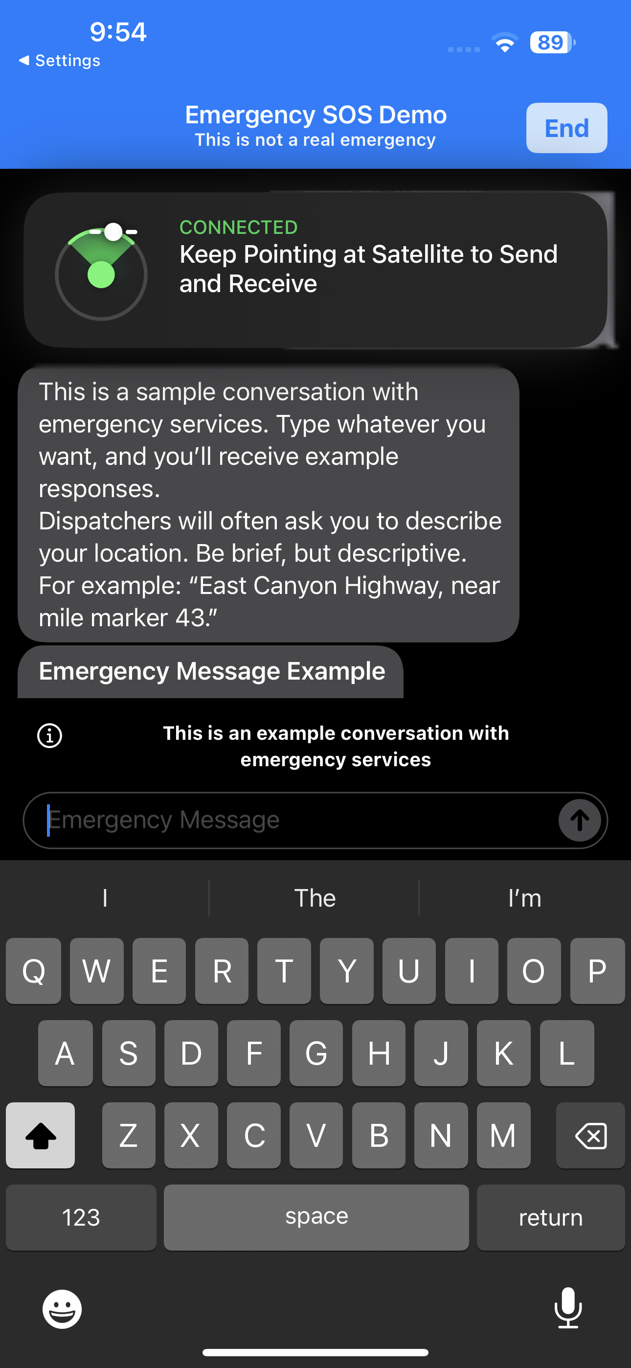
In testing the new iPhone 14’s satellite SOS feature before a trip to Death Valley, where getting lost sometimes leads to death, I reached the following demo screen:
Why would dispatchers ask for your location? Can it be that the iPhone, which knows your 3D position precisely, doesn’t bother to share this with the folks who try to respond to emergencies? In other words, Apple copied all of the features of the EPIRB/PLB except the one that matters: automatically transmitting the location of the person in distress?
If so, it is great for lost hikers who happen to know exactly where they are!
For lost hikers who happen to have 5G mobile data available, Apple offers a help page on the Web that explains a complex procedure for sending one’s coordinates to people who might be able to help. An additional help page seems to contradict the demo screen:
After you’re connected, your iPhone starts a text conversation by sharing critical information like your Medical ID and emergency contact information (if you set them up), your answers to the emergency questionnaire, your location (including elevation), and your iPhone’s battery level.
So maybe the people who wrote this help page and the people who wrote the demo don’t talk to each other?
Once in Death Valley, how did the system work? Fortunately, we didn’t suffer any emergency conditions there. However, after about 2 hours away from mobile data coverage, the phone prompted me to share its location via satellite. Presumably this updated the Find My maps for those with whom I have shared location. It took about 2 minutes of holding/pointing the phone out the windshield of our rental car (the notification hit while my friend was driving).
Another recent interesting Apple user interface issue… a friend in the neighborhood put an AirTag on his dog’s collar. Every time that we walk the dogs together Apple warns me that an AirTag is following me around and do I want to disable it.
Satellite SOS was the only project I created at Apple that actually launched. It was like pulling teeth, but I am glad it is available. When I got to Apple, nobody believed it was possible. The company is 95% status-seeking dead weight, so like the new guy in prison I took my lunch tray and smashed the meanest looking guy in the cafeteria in the face and pushed it through anyway. You’re welcome! 😅
Thank you, Greg. I think you can take credit for saving more lives than Dr. Fauci did with his cloth mask recommendation!
What else did you create that wasn’t released, and can be generally described without violating any NDAs?
Phil, it has indeed saved more than zero lives!
Anon, I also invented some stuff in the smart home area as well as a few wireless & satellite technologies, all things that unfortunately will likely never see the light of day. The smart home remains more trouble than it is worth for most people. The things we could do if not strapped down by overcomplicated wireless standards and communications monopolies remain amazing and unrealized.
> Why would dispatchers ask for your location?
It’s for the same reason that PSAPs typically ask 9-1-1 callers for their locations, even when calls arrive with what appear to be valid Automatic Location Identification (ALI) data: to confirm that the system-provided location is correct and is the place where help is needed (and not just the origin of a call made to report an emergency elsewhere), and to get additional information that might help responders find the scene.
Obviously, if a caller is lost or can give only a rough location, that doesn’t prevent a response to the known street address or coordinates, but depending on the situation, terrain, and weather, a description of the place and how to reach it can save critical minutes of searching.
Apple nerfed AirTags to the point of being useless.
Re:location. Without data connection iPhone can take awhile to take GPS lock since it can’t quickly download ephemeris data. So at the time of the satellite call iPhone might not know location yet.
It’s based on Globalstar’s 10 year old satellite constellation, launched on Soyuzes. Apple partnered with Globalstar at a cost of 1/2 bil to manely upgrade their staffing.
Artist’s Palette scene?
EPIRBs and PLBs both give off homing signal that can be tracked above and beyond the COSPAS/SARSAT datum. So, if you are in the ravine and I can’t see you, your signal is still there. Not so with the iPhone — it is just lat/long to however much precision happened to be there at the time.