A year ago, in the context of hurricane evacuation: Why not a simple web site or phone app to determine whether one must evacuate?
In the latest Texas flooding tragedy, it seems that emergency alerts were sent out to mobile phones. As with hurricane warnings, however, it fell to the individual to determine whether the phone’s current location merited going back to sleep or running for higher ground at top speed.
Why can’t it be a computer’s job to intersect the alert with the phone’s location and, ignoring any sleep silence modes, recommend a definitive course of action? (A year ago, I asked “Why is it a human’s job to do something that can be done much more reliably by a computer?”)
The Wall Street Journal says that flash flood warnings went out, but they weren’t specific:
The National Weather Service said that on Thursday morning it briefed emergency management. By 1:18 p.m. it issued a watch that said locally heavy rainfall could cause flash flooding across eight counties, including Kerr, where Camp Mystic, the girls summer camp that was heavily struck by the flooding, is located. Kerr County is dotted with riverside summer camps as well as recreational-vehicle parks and hotels for vacationers. Overnight it would become the most severely impacted county.
At that time, forecasters expected a maximum of 3 to 7 inches of rain.
The first flash-flood warning—which means flooding is imminent or already happening—came at 1:14 a.m. Friday from the National Weather Service office in nearby San Antonio hours ahead of the Guadalupe’s rise.
Two hours later, the office issued a catastrophic warning, or a flash-flood emergency, for the region.
The warning covered “eight counties” and, in fact, the vast majority of people in those eight counties didn’t have anything to fear. Kerr County alone is 1,100 square miles. The typical resident of the U.S. is not a hydrologist. Why isn’t it a computer’s job to figure out whether a phone is currently located in a river’s floodplain and, if so, provide specific directions regarding how to reach higher ground?
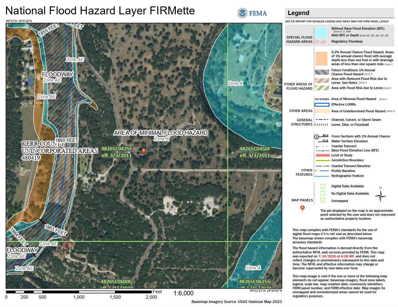
Here’s a FEMA flood map showing what I think is part of the camp at upper right. It shows that there is always an “area of minimal flood hazard” close to any place that has been calculated to be at risk of flooding.
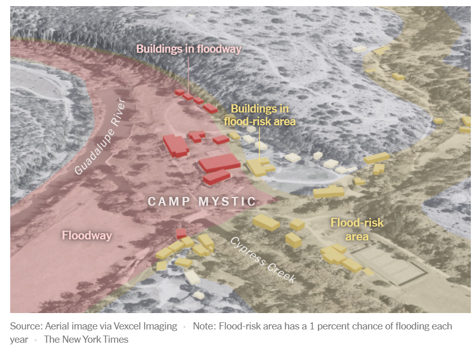
Here’s a photo from the New York Times that shows how close a lot of camp buildings were to areas of perfect safety and how critical a person’s GPS location would be to the safe/unsafe decision.
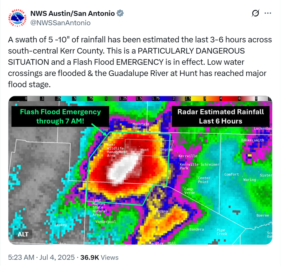
Below is an example warning from the National Weather Service’s X account, which seems to require a lot of interpretation, e.g., knowledge of where one’s location is relative to the Guadalupe River. A typical young American doesn’t know north from south (I remember calling a mobile carrier store on Route 9 in the Boston suburbs and asking the clerk if he was on the north or south side of this road, which run east-west. He was completely stumped by the question and, even after seeking assistance from some fellow workers, couldn’t answer it.) Also, the warnings were issued only in English and Spanish. In a country with an asylum-based immigration system there is no reason to expect someone living in the U.S. to speak either English or Spanish. A phone app, however, can work in any language supported by a smartphone (77 for Android; roughly 40 for iPhone).
The official government attitude seems to be to keep doing whatever failed in the past. In a world where almost everyone has a smartphone (taxpayer funded for those who don’t work), the go-to idea is an early 1900s-style siren system (PBS):
Another idea from the same PBS article is that more humans can be a substitute for a computer system:
> A typical young American doesn’t know north from south
In this case, sorry, $crew the typical young American.
Observing the sun and telling the principal directions was on the first pages of the “World and Man” textbook, recommended reading for Soviet and post-Soviet Russian pre-school/1st grade.
If you can’t tell where you are by simple observation, you don’t know where you are, period.
If it’s going to take a few generations of Darwin to fix that, then so be it.
Don’t make it to the point where the next generation needs to learn Mandarin to survive.
Always wondered how to manetain situational awareness during a loss of all utilities during severe weather. There isn’t going to be any phone network or electricity during a hurricane or tornado. A personal radar station or hard mounted camera might be the best solution. Satellite communication probably won’t work in extreme rain & wind. We need Greenspun back in Fl*rida to test starlink in a hurricane.
Communications and electricity work fine up to the point where people need to evacuate. I am not sure what the value of Internet service would be after a hurricane or flood is on top of wherever one happens to be. If your home isn’t in a safe location you either evacuated to somewhere safe or you didn’t.
this is the fate of the domesticated. in their vanity they think themselves immune to almighty and do not heed her ways.
they worship their glass screens as deities and wonder why the great AI did not save them from the flood which could be easily predicted:
>the camp, located near the confluence of the South Fork Guadalupe River and Cypress Creek, sits within zones the Federal Emergency Management Agency classifies as high-risk flood areas. Both of Camp Mystic’s sites overlap with either regulatory floodways or areas with a 1% or 0.2% annual chance of flooding, CNN reported this morning.
>Officials say the flood was a 1-in-100-year event—rare but not unprecedented.
https://www.newsweek.com/texas-flash-floods-deaths-missing-storms-live-updates-2095388
Maybe the problem iss they relied too much on their phones and not enough on their own eyes and ears. They counted on an outside intelligence to judge risk rather than developing their own.
Helicopter pilots without vfr. does that make sense?
M: I looked at the Newsweek article that you’ve cited. I don’t see anything about the Dolphin (American spelling of Dauphin) helicopters having to fly IFR, though perhaps they did in their journey from the coast. Certainly one cannot do search and rescue operations without some visibility to the ground. The photos and videos I’ve seen of the helicopters operating show weather that is rainy but not foggy.
1 in 100 years? https://www.newsweek.com/flash-flood-alley-has-history-deadly-camp-floods-meteorologist-2095170 is from the same source:
She noted that, while flooding like this “doesn’t happen often,” large scale ones “have occurred at least four times in the last 50 years.”
“Kerrville actually had a higher crest of 37.4″ in a July 1987 event where 10 campers were lost downstream,” Burgess told Newsweek. The crest refers to the highest level a river reaches before it goes back down.
“they worship their glass screens as deities and wonder why the great AI did not save them from the flood which could be easily predicted:”
The flood was predicted and warned about. The original post is about the best way to distribute a warning. Taxpayers have already spent the big $$ required for top quality warnings to be distributed. We spend $6 billion per year on NOAA to get weather and flood forecasts. Google AI says that we were spending $414 million/year in pre-Biden dollars on FEMA flood mapping from 2014-2020. It doesn’t make sense, in my view, to skimp on the final step of merging these data sets in a way that gives a 12-year-old with a phone clear instructions.
I meant the helicopter flying withou vfr as a metaphor for how humans interact with the world around them,specifically the weather, relying on technology rather than their own senses and wits. When you go into the models and underlying math behind weather reports, you see that they are indicative but not definitive and being statistical in nature they do not account well for localized extreme weather, nor the effects sice flooding is as much a geological as meteorological phenomena.
What likely killed so many people, particularly the campers, was hubris — a lack of respect for the power of nature and and over-reliance on brittle systems of technology. Worse, the technological paradigm has become delusional with all things weather vis a vis “climate change”.
I’m ramblin a bit, but my point is that kids will live longer if you teach them the harsh limits of man’s vanity compared to mother nature’s unpredictable furies. Get their nose off a screen and looking at clouds. I guess those poor girls’ parents were trying to do that but they put them in the care of people who apparently did not adequately prepare for a predictable event. Betcha they spent more time worrying about global than local weather.
“the stock market has predicted nine out of the last five recessions”
The weather service has predicted 9 of the last 5 floods. If in doubt, leave your cozy riverside abode or tent, in the wee dark hours during a downpour, go uphill 50 feet or so, and await further instructions from security personnel. Alternatively, consider not staying in flood zones more than a few hours at a time.
Condolences for those who perished or were injured. Thanks to emergency responders.
NO!
While the government has offered Wireless Emergency Alerts for years[0], he camp is too remote for cellular coverage, and, in any case, campers are not allowed to have cell phones (with good reason) [1].
The solution is SIMPLE, AFFORDABLE, and ROBUST: NOAA All Hazards Radio: no home or cabin should be without one[2]. Kerrville (home of Mooney since 1953) is less than 20 miles by road, and substantially closer line-of-sight. Before Bidenflation, they were about $35; they now about $50[3].
The radio is powered by AC mains power with battery backup. In addition to the voice messages, the warnings are digitally encoded (in band) with the warning type, county/counties affected, and duration of the warning. Users can disable all but Tornado Warnings to reduce nuisances (in this case, they should have left the flood warnings on, obviously).
Here is a short video of a radio activation: https://www.youtube.com/shorts/xx_j5a8lduY
[0] https://www.weather.gov/wrn/wea
[1] https://apnews.com/article/camp-mystic-floods-state-inspection-ef17d51dc7868fa9cc5c3076c31ed98a
[2] https://www.weather.gov/nwr/sites?site=WWF90
[3] https://www.walmart.com/ip/Midland-MROWR120B-WR120B-Weather-Alert-1-White/16451519
Thanks, FB. I’m pretty sure that I’ve seen these WEA alerts on my phone for tornados and severe storms, etc. They’re not very specific, though!
I checked out a radio on Amazon and it talks about SAME coding in which there is a six-digit code for each county. That’s nowhere near precise enough to give a human advice on whether to relax in bed or run for the nearest hill. We live in Palm Beach County, 2,386 square miles of wildly different flood and storm surge risk.
Good point.
1) NWS has been working on “partial county alerting”: https://www.weather.gov/pca/
2) The radios alert if any part of your county is in danger, basically “wake up and get clarification.” The alerts themselves generally include a polygon, although that is not read over the air (which is a mistake IMO). I have done some basic proof-of-concept work toward developing exactly the kind of app that you describe.
A longer article on Forbes about NOAA All Hazards Radio: https://www.forbes.com/sites/marshallshepherd/2025/07/06/texas-flood-disasterthe-case-for-a-weather-radio-renaissance/