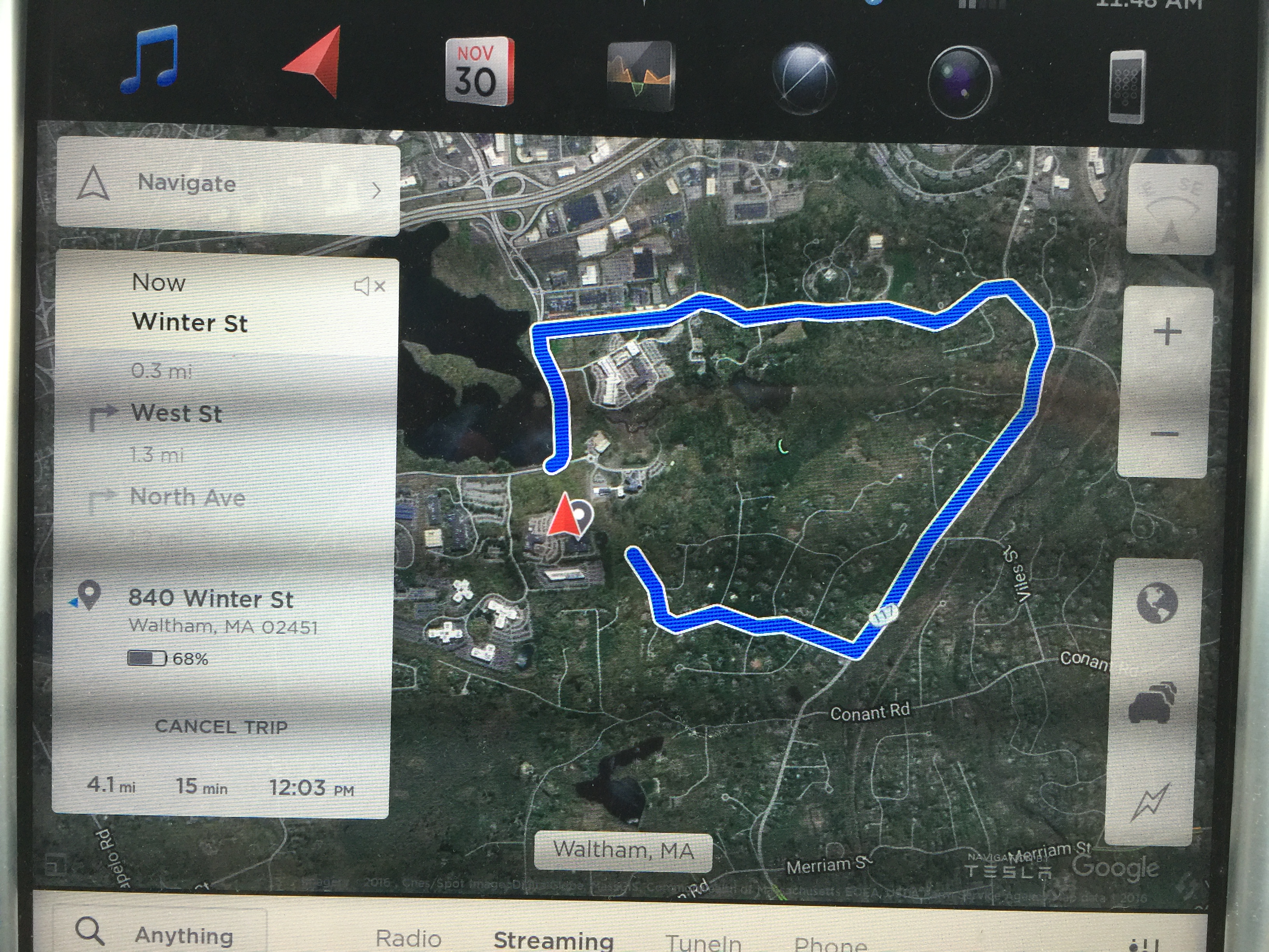
Hoping to save the planet during my annual trip to the gym, I asked my friend with a Tesla X to pick me up. The navigation system kept routing us to a dead-end suburban street from which we could perhaps plunge through backyards to get to the gym parking lot. What about from the gym parking lot itself? Tesla confidently supplied this 15-minute route to the gym:
Related:
The 4.2 mile route is not unexpected and there don’t appear to be any alternatives (that are significantly better) that any mapping program would know about.
Getting directions for 167 Kings Grant Road, Weston, MA 02493 to 840 Winter Street, Waltham, MA 02451 using Google maps produces the same result.
There are no roads directly between the two places (which means, any route is going to be longer than one might naively expect). The gym is in an office complex. Office complexes often are set up so that traffic is not routed through residential neighborhoods.
There is green space (Cat Rock Park) to the east and green space to the north (Valley Brook) that requires going around them. There numerous residential roads but they all appear to be dead-end (that don’t enter the green spaces).
Looking at Garmin’s map, an alternative might be to go west on 117, north on Weston, north on Silver Hill, east on Trapelo, then south on Winter would be the preferred route [b]but there’s something funny about the intersection of Winter Street and Old Country Road (a oneway?)[/b]. And, ignoring that funny bit, that route is longer.
Google maps shows a 2.6 mile route for walking but that’s not even direct.
You are going to a gym that is about mile (might even be less) from your house. If it’s a neighborhood you are familiar with, you might be able to use a route that mapping programs would not know about. And you could have gotten some exercise too.
So, Winter Street *is* a one way where it crosses Old Country Road.
https://www.google.com/maps/@42.4131495,-71.2781197,3a,75y,82.42h,88.92t/data=!3m6!1e1!3m4!1sF8_SsSx8a-hxv1rae-atIA!2e0!7i13312!8i6656?hl=en&authuser=0
You are guessing there are available roads when the maps (2 or 3 different ones) say otherwise.
Davep: You must love driving if you would expect to drive 4.2 miles to get from the parking lot of the gym (at 840 Winter St.) to the gym (at 840 Winter St.)! I can think of a lot of aircraft charter companies that would love to have you as a charter customer. They can bill you for a 4,000 n.m. round-trip from Meridian at Teterboro to Signature at Teterboro!
Hi wonder how much the guys on Kings Grant road pay google to not be on streetview.
(Note that I don’t live on Kings Grant Road. It shows up here only because Tesla’s software thinks that it is the right way to get to the gym (which it might be if you could drive through a McMansion-owner’s backyard.) Google Maps is not similarly confused.)
philg: “Davep: You must love driving if you would expect to drive 4.2 miles to get from the parking lot of the gym (at 840 Winter St.) to the gym (at 840 Winter St.)!”
Most people (myself included) don’t need a GPS to stay at the same place.
philg: “(Note that I don’t live on Kings Grant Road. It shows up here only because Tesla’s software thinks that it is the right way to get to the gym (which it might be if you could drive through a McMansion-owner’s backyard.) Google Maps is not similarly confused.)”
The image shows a big gap between the start and end points.
It seems the odd result might be due to that the parking lot aisles are not in the map.
Andrea: “Hi wonder how much the guys on Kings Grant road pay google to not be on streetview.”
The coverage of streetview is not complete. I know of not-affluent places that aren’t covered.
philg: “I can think of a lot of aircraft charter companies that would love to have you as a charter customer. They can bill you for a 4,000 n.m. round-trip from Meridian at Teterboro to Signature at Teterboro!”
You were the person trying to use a GPS to not go anywhere.
The arrow showing your location in between the start and end point. At that location, there probably are not any roads on the map. Not at all surprising since it’s a private office complex and, likely, fairly new.
davep: “You were the person trying to use a GPS to not go anywhere.” — this assumption turns out to be false. We started from about 5 miles away, typed in the 840 Winter Street address, and watched as the software continually recalculated routes via the Kings Grant dead-end. As reporters were fond of saying during the recent Presidential campaign, the software “doubled down” on its Kings Grant Road bet, even when we were on Winter Street itself and even when we pulled into the gym’s parking lot.
(Note that if we had followed the Tesla’s advice regarding how to drive from the gym parking lot to the gym we would have found ourselves on a dead-end street with no way to get to the gym without hiking through yards and woods.)
The only time I’ve done a route like that was going from the South Rim to the North Rim of the Grand Canyon. LOL.
Looks like the route planner doesn’t know the lot size and shape of the commercial property.
It took your GPS location, decided you were closest to the center of some guy’s suburban lot, and routed you from his house to the street address of your destination.
philg: “davep: “You were the person trying to use a GPS to not go anywhere.” — this assumption turns out to be false. We started from about 5 miles away, typed in the 840 Winter Street address, and watched as the software continually recalculated routes via the Kings Grant dead-end.”
No one has any idea of what you were trying to do because you didn’t say. What you end-up saying here makes whatever you are complaint about more clear.
Anyway, it wasn’t an assumption. It’s based on what you “suggested” you were trying to do here:
philg: “Davep: You must love driving if you would expect to drive 4.2 miles to get from the parking lot of the gym (at 840 Winter St.) to the gym (at 840 Winter St.)!”
This assumption turns out to be false because no one (including you) would ever expect it.
Andrew: “Looks like the route planner doesn’t know the lot size and shape of the commercial property.”
Navigation units have no idea about commercial properties. They only know about roads.
Andrew: “It took your GPS location, decided you were closest to the center of some guy’s suburban lot, and routed you from his house to the street address of your destination.”
This is basically probably what happened.
It’s still not clear what went on (because the situation wasn’t describe very well).
It appears that the issue was related to incomplete data about the roads in the commercial property. As far as the navigation unit understood, the destination (the red mark) was in the middle of nowhere. It’s stuck trying to guess what road it thinks that destination is on (the red mark isn’t literally on Winter street).
Commercial properties are a common place to have limited limited data about. It’s private property and they often are new.
This issue is made much worse because of the line limited roads in the area and the surrounding green spaces.
If there were lots of mapped roads in the area, the problem likely would not have happened. (If the destination wasn’t exactly on a road, the nearest road picked would have likely been good enough.)
The issue might have been partly the result of how the address lookup works. It appears the address lookup is a database of things to lookup mapped to GPS coordinates. (This is what Garmin navigation units appear to do).
The output of the search is just a GPS coordinate (no other information) that the unit has to then locate on the map’s network of roads.
The gym’s physical location (it’s real GPS coordinates) isn’t actually on Winter street. It’s off of Winter street in the middle of a “field” that, as far as the navigation unit knows, you can’t drive to.
Grand canyon boi: “The only time I’ve done a route like that was going from the South Rim to the North Rim of the Grand Canyon. LOL.”
It appears it’s a similar case.
The address lookup yielded GPS coordinates in “the middle of the river”.
If that happens, there isn’t a way of figuring out which side of the river that coordinate is supposed to be at.
The GPS coordinates of the gym were in the middle of a field between Kings Grant and Winter street.
The real issue is that the commercial property is not well mapped (not an uncommon thing).
At least we know that when the robots come for us, it will take them a while.