Hanna Reitsch’s kamikaze dream
A third post based on The Women Who Flew for Hitler, a book about Hanna Reitsch and Melitta von Stauffenberg.
The Germans were great at innovation, but the Allies built so many old tech bombers and escort fighters that it was tough for the Germans to exploit their innovations. Regarding 1943:
The Peenemünde facility had been established in the 1930s by Wernher von Braun. A political conformist brought up with right-wing, nationalist values, Braun had joined the Party in 1937, and the SS three years later. After graduating with degrees in mechanical engineering and applied physics, he persuaded the military to fund a development centre at Peenemünde: a location his mother had recommended, knowing it from her husband’s duck-shooting holidays.*
By April 1943 the threat of V-weapons had been prioritized [by the English], and the ‘Bodyline’ organization was convened to develop a response. Peenemünde was now identified as the principal research facility. Working in shifts around the clock, and largely sustained by Spam sandwiches and coffee, Constance Babington Smith’s team was on alert to look out for anything ‘queer’ that might be a long-range gun, a remotely controlled rocket aircraft, or ‘some sort of tube … out of which a rocket could be squirted’.
Peenemünde was [raided in August 1943] with wave after wave of bombers passing over the site without any aerial counter-attack. … British Bomber Command had sent a massive assault force of 597 aircraft to drop between 1,500 and 2,000 tons of high explosives on Peenemünde in Operation Hydra. This was almost the entire bomber fleet – an enormous risk for one mission. Surprise was paramount to mitigate that risk. Once fed and briefed, the RAF pilots had been sworn to secrecy and locked into their hangars. Regular bombing raids on Berlin had been undertaken in the weeks before, in the hope that the Germans would assume this was still the target. A ‘spoof attack’ on the capital by British Mosquitoes was also planned; and fine strips of metal ‘window’ were dropped to blind the German radar.
Five days before Christmas [1943], the US Eighth Air Force started to bomb the V-1 launch sites in northern France, to prevent a winter attack. Eventually they would obliterate every one. ‘The first round of the battle against the flying bomb was an overwhelming victory for the Allies,’ Babington Smith wrote with some flourish.
Without the P-51 Mustang to provide long-range escort, these types of raids required incredible bravery. Forty British aircraft were shot down after the Germans figured out what was going on and sent fighters from Berlin. The bombings made the typical German understand that continued armed conflict wasn’t going to be effective. Hanna came to the same conclusion, but responded differently:
… as the aerial bombing of Germany intensified, civilian morale plummeted and the regime had to apply increasing oppression and compulsion to maintain order. Over the course of 1943, the German courts passed more than a hundred death sentences every week on citizens deemed guilty of defeatism or sabotage.
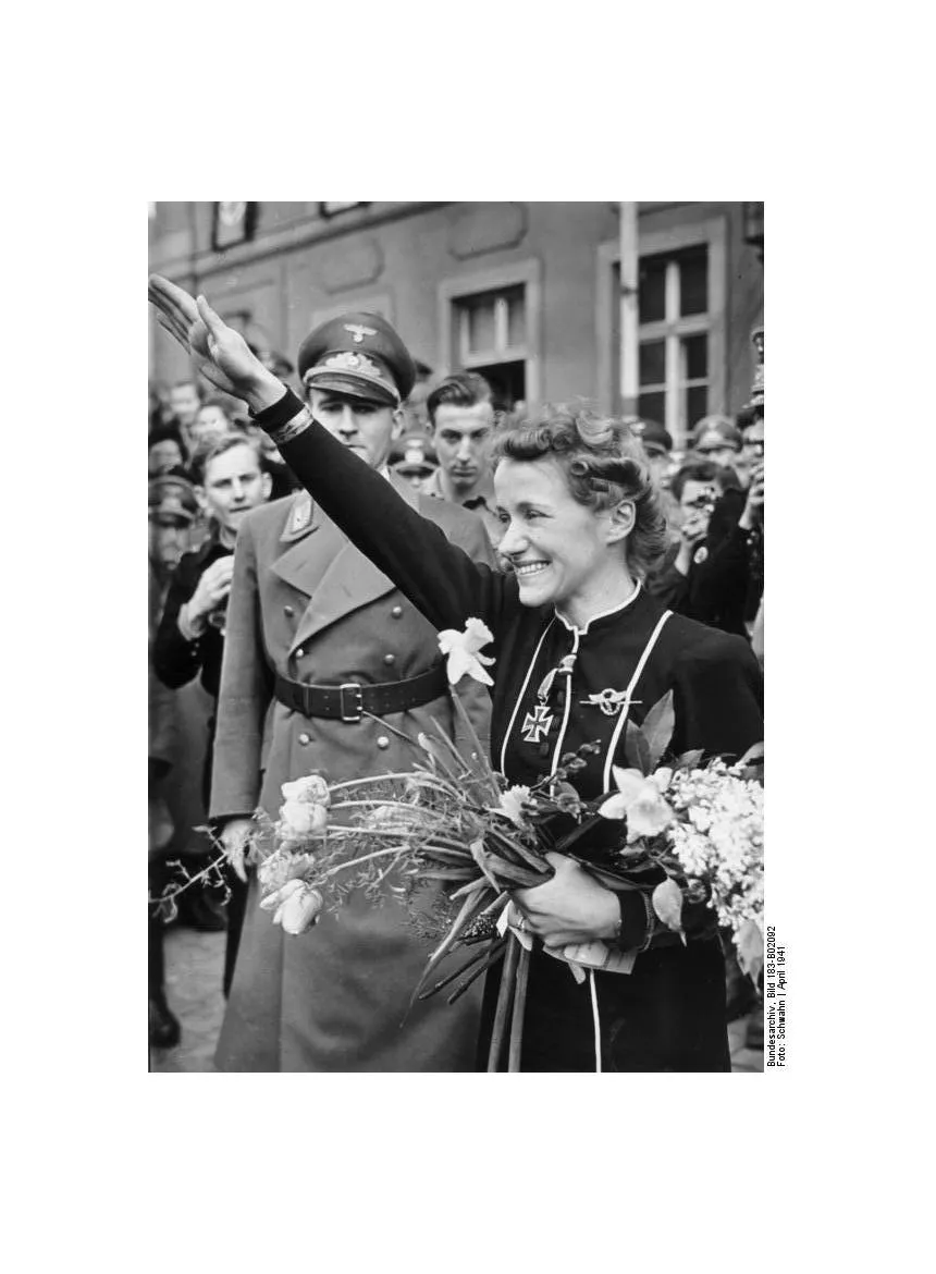
Unlike Melitta, Hanna had never doubted the aims of the Nazi regime. Even she, however, had now lost faith in the promised certain victory. ‘One after another, towns and cities were crumpling under the Allied air attacks,’ she wrote. ‘The transport system and the production centres were being systematically destroyed … the death toll continually mounted.’
Hanna knew that the precision of these air attacks was critical to the success of her plan. Melitta’s work with dive-sights and dive-bombing techniques had greatly improved accuracy, but Hanna had something more radical in mind. She wanted pilots, potentially including herself, to guide their missiles right down to the point of impact – without pulling out. With shipping targets, one paper outlined, ‘the plane was expected to shatter upon impact with the water, killing the pilot instantly and allowing the bomb to tear loose from the plane to continue under the keel of the vessel, where it would explode’.9 Although the pilots ‘would be volunteering for certain death’, Hanna added, ‘it would be no task for mere dare-devils … nor for blind fanatics, nor for the disenchanted and the life-weary who might see here a chance to make a theatrical exit …’ What was needed, she felt, were measured and honourable men, ‘ready to sacrifice themselves in the conviction that only by this means could their country be saved’.
Why everyone needs a marketing expert:
[Hanna] named the fledgling plan ‘Operation Suicide’.
It seems that having a wife and kids drove at least some men to think of suicide…
Nevertheless, as word of Hanna’s proposed suicide squadron spread, she began to receive discreet enquiries from other zealous pilots, enthused by the thought of sacrificing their lives for Hitler’s Germany. Encouraged, Hanna sought out more volunteers. ‘We found them everywhere,’ she wrote with satisfaction. Most ‘were married and fathers of families and were robust, uncomplicated individuals. As they saw it, the sacrifice of their lives would be as nothing compared with the millions, both soldiers and civilians, who would die if the war was allowed to continue.’
Adolf Hitler was a moderate compared to Hanna Reitsch and pointed out that “There was no precedent in German history and the German public would not stand for it.” Hanna eventually wore him down, however, and she was allowed to work on her pet project. The suicide machine was going to be an air-launched V-1:
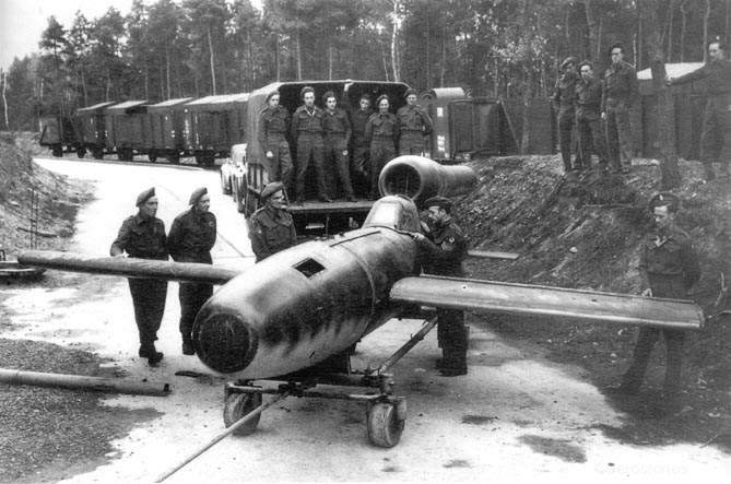
Various test and training versions of the manned V-1 had now been developed. Some had twin seats and dual controls for instructor and student, while others were single-seaters. Most had power units and all had landing skids, but landing even an unarmed V-1 remained extremely hazardous. ‘Pilots of an average ability could never be certain of surviving the attempt,’ Hanna wrote bluntly.
By the time that Hanna and Skorzeny reached Rechlin, a prototype V-1 was already ‘nestled’, as Skorzeny described it, under the wing of a Heinkel He 111 bomber, ready for take-off. All went well as the Heinkel lifted from the ground and began its ascent. When the V-1 pilot detached his machine from the bomber, Hanna watched it ‘drop away … like some small, swift bird’. The V-1 flew at twice the speed of its Heinkel mother-plane, tearing away through the sky. After a few wide circles it began a smooth descent. Suddenly the pilot lost control. Moments later the V-1 crashed to earth, its point of impact marked by ‘a column of black smoke rising in the summer air’. While most of the observers still stood watching in horror, Skorzeny impatiently called for another test pilot, before striding off. ‘Always a gentleman …’ Hanna later defended him: Skorzeny ‘demanded more from himself than from his men … [and] won the hearts of the soldiers committed to his care’. Incredibly, although badly injured, the V-1 pilot had survived. The crash was blamed on manual error. A second attempt, the next day, brought a similar result. According to Skorzeny, when the Air Ministry ordered an end to the programme, Hanna ‘could scarcely hold back her tears’.
Hanna persuaded the SS hero Skorzeny to let her fly the machine herself:
Despite her rubber-lined leather helmet, Hanna must have been deafened by the noise of the Heinkel’s engine and the battering of the slipstream on the V-1 as she was dragged into the air. Nevertheless, her release was perfect. As the V-1 engine began to stutter, Hanna dropped from her host and pushed the tiny missile to its cruising speed of around 375 mph. ‘The handling of the machine and its beautiful circles soon showed what an amazing pilot this girl was,’ Skorzeny noted in admiration. Nevertheless he still broke into a cold sweat as Hanna brought the V-1 spiralling down. Since the missile was not designed to land, once the engine cut out she found it cumbersome, gliding down steeply, ‘like a piano’. Moments later she managed a fast but smooth touchdown on her skids, blowing up clouds of dust across the tarmac. ‘Nothing wrong with it at all,’ she proudly told the engineers who rushed up to meet her. Milch reportedly ‘turned pale’ when told of the unauthorized test but, as Skorzeny emphasized, ‘both the idea and the machine had been vindicated’. ‘Passed without incident,’ Hanna recorded simply in her flight report. She and Skorzeny were jubilant, and the project was given clearance to proceed.
The Normandy invasion rendered the project moot because Germany needed all of her pilots for defense.
The Fieseler Fi 103R Reichenberg: